Deep Dive: Floodplain Protection & Restoration
Over the past thirty years, the science guiding how we manage our rivers has been evolving to emphasize the river as a whole system. Past approaches prioritized constraining the river into a stable and predictable channel to control the delivery of water downstream and reduce flooding risk. This approach has devastated river health and degraded the multitude of essential ecosystem benefits that sustain our communities, economies, and the environment.
An emerging tool in the resiliency adaptation toolbox aligns the management of water resources, land use changes, and potential hazards to improve benefits for communities and the environment in an equitable manner. There are many names for this new paradigm—nature based solutions, integrated river basin management, integrated floodplain management (IFM), and more.
Below, we take a closer look at examples from Washington and Vermont where those states have developed IFM programs.
Vermont Functioning Floodplains Initiative
The Vermont Rivers Program, within the Agency of Natural Resources Department of Environmental Conservation (DEC), houses a multidisciplinary program staff paid for by a suite of federal and state agencies including Federal Emergency Management Agency (FEMA), Environmental Protection Agency (EPA), and the state Water Quality Division of the DEC. This program is charged with river corridor and floodplain protection, among other responsibilities and it “promotes the planning, designing, and protecting of river corridors that will accommodate stream meander and floodplain processes as the most economically and environmentally sustainable river management alternative.” In addition to its regulatory authority, Vermont DEC also uses the River Corridor Easement Program to protect river corridors. Landowners are encouraged to sell their river channel management rights to a land trust to prevent new structures or development and require at least a 50ft buffer of native woody vegetation. The Functioning Floodplain Initiative is another powerful tool in the Rivers Program’s toolbox.
For years, the Rivers Program has developed Stream Geomorphic Assessments to assess the condition of the rivers in Vermont. These analyses result in river corridor plans, which have been used in “basin planning; river and riparian corridor protection, management, and restoration projects; aquatic and riparian habitat assessment; and hazards assessments to reduce property loss and damage from riverine erosion during floods.” (Source)
The Functioning Floodplain Initiative (FFI) is a new web-based decision support tool to track program and practice gains in floodplain and watershed connectivity and function, derived from new generation data (e.g., LiDAR data) and existing information from decades of Stream Geomorphic Assessments of the states’ river systems. The Initiative has developed interactive tools that can identify high priority, nature-based projects to protect and restore stream, wetland, and floodplain functions through modeling and benefit-cost analysis.
The overarching goals of the Initiative are:
- Water Quality: Free of excessive sediment & nutrient discharges
- Flood Resiliency: Minimal damage from inundation and fluvial erosion
- Ecological Integrity: Viable, native plant & animal communities
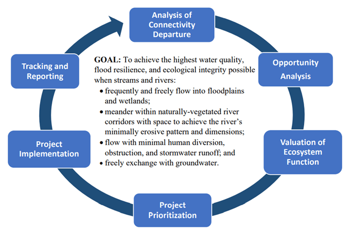
The web-based mapping tools are intended to be helpful at three different scales: basinwide regional planning, selection of groups of projects to achieve multiple objectives, and development of individual projects.
These tools are currently being used to calculate load reduction credits for restoration and protection projects associated with meeting the requirements of (and getting funding to meet) the Lake Champlain Phosphorus Total Maximum Daily Load (TMDL). Once a preliminary design is created in the FFI tool, the project co-benefits of flood and fluvial erosion reduction (loss avoidance) and instream and floodplain habitat are generated by the FFI tool.
The FFI is a branding of a philosophy and approach that the Vermont Rivers Program has embraced and promoted since the 1990s. Support for the approach was broadened after Tropical Storm Irene hit Vermont in 2011 with more than seven inches of rain in some places. This rain increased the volume and power of the states’ mountain streams so dramatically that it claimed lives and caused damage to over 500 miles of roads and 200 bridges. Federal assistance totaled more than $600 million to help meet the hefty state, local, and individual costs incurred. This dramatic event was not Vermont’s first (since 2000, more than one federally-declared disaster per year), nor was it Vermont’s last. In July 2023, following an above average rainfall for June, another devastating flood event occurred after an extremely heavy rainfall that exceeded nine inches in one day in some places. What’s worse, the rain continued for a few days after that.
Between the two events, however, the Vermont General Assembly passed several pieces of legislation directing the establishment of the River Corridor and Floodplain Protection Program “to promote and encourage the identification and protection of flood hazard areas and river corridors to reduce flood and fluvial erosion hazards.” For more, read their published Procedures.
Read Mike Kline’s full Lessons from the Network interview to learn about VRP’s FFI approach and more.
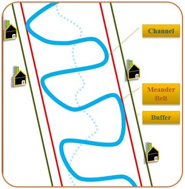
Floodplain activities in Vermont are regulated through multiple jurisdictions:
- Municipalities regulate flood hazard areas as required for enrollment in the National Flood Insurance Program;
- Municipalities are encouraged to adopt river corridor protection bylaws, but are not required to do so;
- The State regulates flood hazard areas and river corridors for larger projects requiring a land use permit (see Act 250); and
- The State regulates flood hazard areas and river corridors through Flood Hazard Area and River Corridor Rule for activities exempt from municipal regulation. Such activities include state-owned and operated institutions and facilities; accepted agricultural and silvicultural practices; and certain power generation, transmission, and telecommunication facilities.
The minimum standards required by the Federal Emergency Management Agency (FEMA) strictly protect the floodway, but they don’t effectively restrict what happens in the flood fringe of the mapped 100-year floodplain called the Special Flood Hazard Area. Vermont’s Rivers Program, which administers the River Corridor and Floodplain Protection Program as well as others, addressed the need for protections within the Special Flood Hazard Area by mapping the riparian areas along rivers and by developing the Flood Hazard Area and River Corridor Rule. The Flood Hazard Area and River Corridor Rule set a “no adverse impact” standard for new developments proposed within river corridors, with exceptions for infill and redevelopment.” For more, read Mike Kline’s Lessons from the Network interview.
The Flood Hazard Area and River Corridor Rule applies to activities that are exempt from municipal regulation. The rules and permits associated with them are intended to ensure development enhances flood resilience; complies with the National Flood Insurance Program criteria; is consistent with public health, safety, and welfare; and does not impair floodplain services, or the stream equilibrium processes within river corridor.
Additional Resources
- Functioning Floodplain Initiative User Guide, 2023.
- Flood Hazard Area and River Corridor Protection Procedure, Vermont Agency of Natural Resources, Department of Environmental Conservation, Sept. 2017, p.4. (last visited 6/30/24)
- Giving Our Rivers Room to Move: A New Strategy and Contribution to Protecting Vermont’s Communities and Ensuring Clean Water, Mike Kline in the Vermont Journal of Environmental Law, Vol. 17, 2016.
- River Corridor Planning and Protection
- VT Agency of Natural Resources River Corridor Planning Guide, April, 2010
- River Corridor Easement Program
- Act 250 – Vermont’s land use and development law
- Flood Ready Vermont – supports community planning
- Flood Training – supports local administration of river corridor and floodplain regulations
- Resources for the Public
- Resources for Municipal Officials
- River Corridors and Frequently Asked Questions
- Community Reports – summaries of risk data and community efforts
- Vermont FloodReady Atlas – online map with popup reports
- Update Your Plans – flood resilience, hazard mitigation and emergency operations
- Emergency Relief and Assistance Fund (ERAF) – qualify for more aid after a disaster
Floodplains by Design
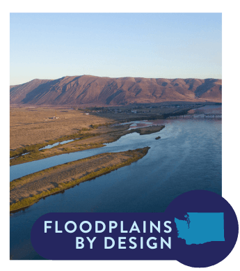
Floodplains by Design (FbD) is a creative initiative based in Washington State. It was developed to break down funding silos that have historically existed among flood, farm and fish interests and support collaboration among Tribal, local governments, agricultural interests and local communities working to protect and restore salmon habitat, increase flood resiliency, and improve water quality.
Even before climate change started affecting us, everyone was losing: flooding continued to grow; farmland continued to be lost; salmon continued to decline; water quality continued to decrease. Climate change has exacerbated these realities, and continuing to do the same thing we’ve done for decades is not working.”
– Bob Carey, The Nature Conservancy in Washington
Bob Carey with The Nature Conservancy in Washington was the original architect of the FbD program, and he has transitioned to help spread the word about its success around the country and to incubate similar programs in other states.
The FbD program envisions a future in which partnerships, policies and practice collectively encourage integrated management of Washington’s floodplains, leading to strong community relationships, healthy salmon runs, vibrant agriculture and infrastructure out of harm’s way. Floodplains by Design also supports projects that provide other benefits that are important to local communities, such as expanding access to culturally important resources and recreation.
Floodplains by Design is an ambitious public-private partnership that is comprised of:
- A multi-million dollar capital grant program led by the Department of Ecology (Ecology).
- This includes technical and grant management services provided by Ecology, and co-leadership/participation in Floodplains by Design action and advisory groups.
- Dozens of local governments, Tribes, NGOs, agencies and landowners who build partnerships to plan and implement projects and are continually working to improve floodplain resilience.
- This includes creating and sustaining local collaboratives to advance funding and implementation of integrated floodplain management projects
- And an NGO “backbone” team currently led by Bonneville Environmental Foundation that works in partnership with Ecology staff and seeks to sustain and grow integrated floodplain management funding, policy and practice in Washington State.
- This includes co-leadership of Floodplains by Design action and advisory groups and related work, support for grant program implementation and communications, and activities aimed at developing capacity, knowledge sharing, increasing funding and advancing productive policies to support integrated floodplain management.
Governance and Framework
The “FbD network” is comprised of tribes, local, state, and federal agencies and governments, nonprofits, special purpose districts, community members, academics, policymakers, and others who are advancing integrated floodplain management in the State of Washington.
Work falls under three categories: 1) communications, 2) capacity, and 3) funding and policy. The vision is set and upheld by a Steering Group, and Ecology and the NGO backbone meet regularly through several forums, including and Operations Team, which facilitates a Grant Management Group and a Communications and Collaboration Group. The NGO backbone and Ecology co-lead a Culture and Capacity Action Group and a Funding and Policy Action Group that meet regularly and offer a space for information sharing, peer to peer learning, and other network convenings.
FbD Network activities
Source: Floodplains by Design Selected Cumulative Grant-Funded Outcomes, 2013-2023; Bonneville Environmental Foundation.
| Activity | Frequency |
|---|---|
| Culture and Capacity Action Group - provide guidance on topics and timing | Approximately 10 lunch and learns per year |
| Funding and Policy Action Group | Approximate quarterly meetings |
| Convenings | At least once per biennium |
| Communications Plan | Biennially |
| FbD Backbone Website | As needed, typically at least quarterly |
| FbD Newsletter | Typically every other month, with additional briefs as needed |
| Project one pagers and communications materials | Biennially |
| Revisit and revise purpose and invites to groups | Biennially |
| Tribal Convening | Annually |
| Steering Group | 3-4 per year |
| Operations Group | Monthly |
| Leadership Meetings and Conversations | As needed, typically biweekly |
| Backbone Tribal Liaison | Typically weekly |
| Informational site visits, tours and meetings | Variable |
| Conferences and gatherings | Variable |
Floodplains by Design Grant Program
The focus of the FbD grant program is to support local entities working to advance IFM at a river reach or basin scale. FbD grants can support both on-the-ground floodplain protection and restoration projects and the partnership development and sustainment needed to scope, design, and administer projects that can have such wide-ranging impacts. Most applicants are counties and cities, Tribes, and local organizations such as watershed-level “lead entities” for salmon recovery.
Most of the grants are multimillion dollar awards. Ecology has chosen to set a soft cap of $10million per project to help spread the funds around to more communities. The 2023 package was the largest pool of funds to date at $64.5 million due to additional funding associated with the passage of the state’s Climate Commitment Act.
The total FbD funding request each biennium includes a grant for the NGO backbone Team to support the work described previously. Ecology also requests an administrative fee equal to 3% of each grant to run each grant cycle, and provide technical and financial oversight for each project and the program as a whole.
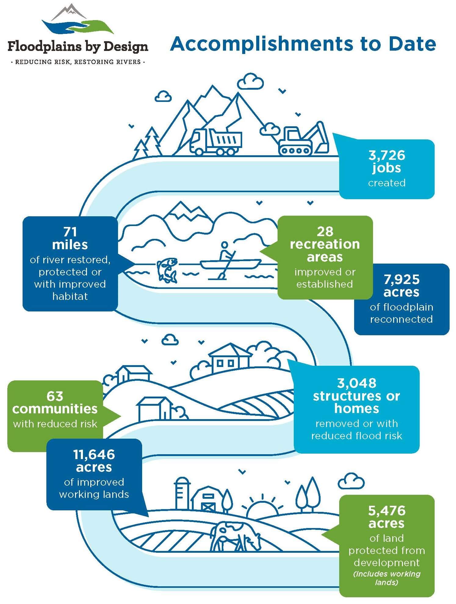
Interestingly, FbD is not established in state law or administrative rules. The overarching vision is articulated and implemented through the grant program funding guidelines. The grant program has always incentivized broad collaboration and the hard work associated with forging partnerships to collaboratively identify, plan, and develop projects at a river reach or basin scale. In 2023, the grant program turned 10 years old, and Ecology and the NGO Backbone Team prioritized working together on making more substantial updates to the funding guidelines for the next grant round (the state’s 2025-27 biennium) than had been attempted previously. Priorities for those updates included but were not limited to making the application process more efficient; providing a more robust orientation for the evaluation team; and looking for specific opportunities to improve diversity, equity, inclusion, and/or address environmental justice concerns.
Capacity building that FbD grants fund includes:
- Project Management Resources – collaborative work, permitting efficiencies, contracting efficiencies
- Interpersonal Engagement – building trust with diverse stakeholders and engaging with unhoused communities living in the floodplain
- Communications Resources – building support for the vision
- Research and Monitoring – collection and analysis of data, adaptive management
- Tribal Engagement Resources – deeper understanding of Tribal governance and history within Washington boundaries, tools and techniques to collaborate with Tribal Nations
At the local level, groups self-organize into “flood, fish and farm” collaboratives often with a local organization serving as the convener to bring different interests together around identification of needed integrated actions, funding, and project implementation. Members of the local focused collaboratives coordinate on project implementation and adaptive management. This may also include development of plans dictated by laws and/or regulations such as state Comprehensive Floodplain Planning, FEMA Hazard Mitigation Plans, state Water Resource Inventory Area (WRIA) salmon recovery plans, and state Growth Management Act-required local Comprehensive Plans and Shoreline Management Plans. Some collaboratives have also developed their own Agriculture Resilience Plans (see Snohomish County’s Sustainable Lands Strategy, for example).
Additional Resources
- Floodplains by Design
- “Addressing inequities and meeting needs of Indigenous communities in floodplain management” by Olivia Zimmerman and Tanya Eison, with support from Robert Carey and Phillip S. Levin.
- Floodplains for Whom? – A research project confronting inequities and supporting needs of Indigenous communities living near floodplains in the Pacific Northwest, Olivia Zimmerman, June 4, 2022 (story map to accompany article)
- Nature Is podcast, Episode 107, “Breaking Down Silos: Collaborative Floodplain Restoration” (4/16/2024). In this episode of the “Nature Is” podcast, host Lara Birkes explores the Floodplains by Design initiative, an ambitious public-private partnership focused on restoring river corridors and reducing flood risks in the Pacific Northwest using nature-based solutions. Guests Bob Carey from The Nature Conservancy and Kathleen (Kas) Guillozet from the Bonneville Environmental Foundation share insights into this pioneering collaboration.
